

THE LONG WAY HOME
April 29, 2019
Report & Photos by Joel Brewster
What would possess someone to want to hike all the way from Kyle Canyon Road to their house? A legitimate question, but I would say "Why not?" Since I live on the west side of town, it seemed intriguing to hike from Kyle Canyon Road to my house. It had been in the back of my mind for a couple of years, but I finally decided to do it. I had scouted out some of the route, and had pored over topos and Google Earth, but there was one section of the planned route that looked very daunting (steep cliffs and sketchy class 4-5 terrain) on the east side of Peak 6080 (the long brown ridge separating Kyle Canyon from the Las Vegas valley).
Fortunately, Chris M., Laszlo, and I had gone on a recon hike the week before. We found a route up through the cliff bands that was no more than class 3, and mostly just steep class 2. This made me feel much more comfortable about the prospect of descending this section.

Beautiful flora just as I start to climb the ridge up to Peak 6080

Clouds building
As the date for my proposed outing approached, the weather was not cooperating. High were predicted in the 90's, which would have been doable, but unpleasant, and would have necessitated bringing much more water. I decided to reschedule for the following Monday, which was predicted to be in the 70's with a chance of rain and thunderstorms. This sounded much better to me.
My planned route would entail approximately 9 miles, 2700' of elevation gain and 4200' of elevation loss...piece of cake, right? The plan was to have my son drop me off on Kyle Canyon Road at the 4300' level on his way to school, which he agreed to do for a small fee.

Looking back up to the ridge as I descend
“Sure, Dad, I’ll drop you off on the side of the road before I go to school. That doesn’t sound weird at all.”
As I began hiking along the old road, then up the ridge, it was partly sunny and a pleasant temperature. However, I worked up a sweat quickly, as my ascent was quite steep. It was a beautiful morning for a hike, but as I approached the summit, I noted some black clouds hanging over Mount Charleston. Then I noticed lightning striking the summit of Charleston, not just a quick bolt, but what looked like a continuous strike! It looked like something straight out of a weather special!

A flowering yucca down in the wash
Fortunately for me, the clouds looked far away. But just as I summitted I heard thunder, and not far away, but quite close! Needless to say, I didn't spend much time on the summit. I was worried because my planned route had me follow the ridgeline for 10-15 minutes before dropping off the steep east face. As I hightailed it along that ridge, several loud thunderclaps spurred me on.
Luckily, once I started the descent, I didn't hear any more thunder. The descent route was a bit tricky to follow, but other than a few minor route-finding issues, it went quite well. It did rain and hail on me a bit, but it only lasted a few minutes.

Looking east down Box Canyon, it looks like a nice day...

But looking back to the west, the clouds look ominous!
Once off the ridge, came the one part of the journey I had not hiked before. This section involved going up and down a few minor ridges and finding my way into Box Canyon (without cliffing out in the narrow section of the canyon). It was pretty easy-going for a while, but then I decided to follow a wash down. This was great at first, but I soon was stopped by a series of dryfalls. This forced me to exit the wash on steep, loose slopes, and parallel it until I was past the difficulties. This was a bit tedious, but worked okay.
Once finally in Box Canyon, it was easy walking down the wide wash as I passed Lonely Pinion Peak. Then I was in terrain I knew well, so the rest of way home should be a simple walk in the park, right? Not so much!
As I walked along looking east toward Las Vegas, it was sunny, but then I turned around to see where I had come from. Threatening dark clouds blocked out the sun and they were coming my way! I estimated I had an hour and 15 minutes to get home, and wondered if I could make it before the clouds overtook me. I actually considered running to try to make it home dry, but as it turned out, unless I ran like Usain Bolt (not likely), it wouldn't have mattered much.
I tried to hike at a good pace, but in a few minutes, the sunny skies disappeared, and it got very dark! Soon the rain came, and came it did. It POURED - I was soaked to the skin within minutes. The rain actually felt pretty good as the air temperature still wasn't too cold. I was actually enjoying my walk in the rain...until the the lightning started! For a half an hour or so, I was serenaded by earsplitting thunder and the lightning that went with it. It was disconcerting, but I didn't notice my hair standing up (maybe because I don’t really have enough hair?), so I never felt too panicked.
Fortunately, the thunder and lightning stopped a mile or so from my house, and I could enjoy the final leg and observe the desert during heavy rain. It was quite cool to see the old dirt road on which I was walking turn into a raging river!
All in all, it was a fantastic and memorable day. It took me a bit over 6.5 hours, and I got to see a wide variety of weather along the way. I hope to post this trip again in the fall or next spring, hopefully with less "exciting" weather!

The road behind my house turned into a river!
“ALP”-INE ADVENTURE
September 2018
Report & Photos by Ed Forkos

Trip to the Alps
As part of our visit to Europe, Luba and I decided to visit the Alps to hike and sightsee. We’re very sorry that we did not do this at a younger age. It was an experience of a lifetime.
Our first stop was the Zillertal in The Tirol (Austrian Alps) 9/2-8/2018.


We chose one of many well-established resort valleys known for magnificent scenery and great access by cable car to the high country. The village of Mayrhofen high up in the valley is logistically very well-located. We stayed on the edge of the village, near the main road, at the Hotel Garni Glockenstuhl, a small boutique 3-Star, with excellent breakfasts; very clean, modern and well-priced. In general, Austria is vastly less expensive than Switzerland, but just as nice.

I had trouble finding good, reliable hiking information in print, so I relied more on online sources which were just okay. The best maps and info were actually available at the ski lift offices, and free. In the Ziller valley, there were about 12 lifts running through the summer. They are pricey, about $25-40 per person for out and back, one day, but they are worth it to gain a few thousand feet to get to the great alpine terrain quickly. On debarking the lifts, you’re greeted with excellent signage and great restaurants.
Beware that the weather has much more rain and fog than the Sierras or even Colorado.

I highly recommend a membership in the German Alpine Club (Deutscher Alpenverein) to get evacuation insurance at a nominal cost.
We were fortunate to be able to hike every day hitting perhaps some of the best routes that are moderate for distance and elevation gain, despite some rain, and enjoyed the experience. Rock quality is basically good, but rocks are often wet. There can be considerable mud on the trails. Here’s what we did:

Ahornspitze, 2973m, Class 3 exposed summit block
Hintertuxer Glacier area at the top of the Zillertal, including an excellent interpretive trail on glaciology, Tuxerjoch Spitze, 2338m, small, but with a Class 4 summit block,
Frauenwand, 2541m, and Weisswand


Kreutzjoch, 2558m, some Class 2
Drive to the Schlegeisspeicher (reservoir) on a scenic toll road, then hike on trail to the Pfitscherjoch at 2246m, the lowest pass into Italy, very dramatic
Loop hike through Grublspitze, 2395m, Ramsjoch, 2508m, and Waldhoaralm, Class 2- with considerable exposure in places, very muddy at timer.
We then drove south into sunny Italy for one week in the Dolomites. This is a large region of massive, dramatically sculpted, limestone-like barren cliffs and pinnacles in the Italian Tirol.

THE DOLOMITES


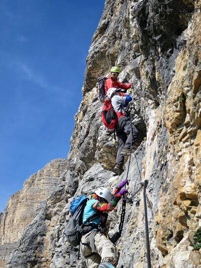
We went there to specifically climb Via Ferrata routes, an extensive system of cables dating back to World War I, created for military defensive purposes, now transformed into a recreational industry. Because we wanted to focus on the more technically difficult climbs, where efficiency and safety become critical, we enlisted a guide service, On Top Ltd, out of Canada, catering mostly to English speakers, but using expert local talent. This also proved to be quite economical as we paid about $2000 per person for 7 nights, daily breakfast and dinner in a 4-Star hotel, plus guide service and use of the equipment. Our guide, Walter Andrighetto, was superb, demonstrating an extensive knowledge of the terrain, the weather, the logistics of access etc., but remaining very flexible in the planning process based upon the make-up of the group and their interest. He could be contacted for private guiding as well. We had a small group of 5, and all were experienced climbers. So we focused on some of the most challenging routes in the area around Alleghe, where we stayed at the Sporthotel Europa.

We chose to avoid the high huts (refugios) in order to have better food and rest, and concentrate on the climbing.
The Vias that we did were not lightweight! They were mostly Class 5C, the maximum difficulty rating. There were moderate to long approaches and returns, 1500-3000 vertical feet of actual climbing, most at the Class 4 and 5 level, done at a quick pace to stay ahead of the weather, massive and sustained exposure: long, strenuous days. Finding the starts was not easy. At this level, it’s more akin to sport climbing, but with more frequent clipping into protection. Falling is really not an option. There were very few artificial footholds, so you needed good footwork, often on vertical to occasionally overhanging walls. Though you could pull on the cable as a handline, this was not always the best option except for downclimbing. You’re connected to the cables by two 3’ tethers with a built-in screamer. Falling onto this provides very little shock-absorption, like a dynamic climbing rope. Class 3 sections, often exposed, lacked protection. Patches of snow and ice are sometimes present on the route even in the summer. Class C meant commitment: there were few bailout points. Rock quality on the faces/ridges was good, but the ledges were prone to having lots of loose talus and scree. So this was a real mountaineering experience! Of course, lower level vias are proportionately easier overall, and many could do Level 1-2A safely on their own. Below was our itinerary:
VF Trincee, west to east, 5C, 5 ½ hrs, some old war tunnels to explore

VF Tomaselli, 5C, 6 hrs
VF Constantini, 5C, 10 ½ hrs, the classic Moiazza traverse; descent tricky on unstable Class 3 slopes
The Marmolada via the west ridge, one of the iconic routes, 4B, 7 ½ hrs; a mixed route requiring crampons on the glacier on ascent and descent, with a long, confusing Class 3 downclimb further down. Metal stempels in place on vertical pitches.


VF Caesare Piazzetti, 5C, very difficult and sustained climbing; descent involves a severely exposed traverse across a steep scree slope.
VF Alpini, at level 3, done to avoid afternoon weather, was noticeably much easier and quite pleasant, but quite crowded!
Feel free to contact me if you have further questions about the Alps as this was a very brief report.
LVMC BIO FEATURe
Susie Nichols

Where were you born?
I was born in Litchfield, Illinois. I have since lived in Montana, Washington, Colorado, Florida, North Carolina, and now Nevada. Colorado has been my favorite but Nevada is a very, very close second.
How long have you lived in Las Vegas?
I have lived in Las Vegas for seven years.
What is your occupation?
I manage a graphic arts department for a church directory company.
How long have you been an LVMC member?
I’ve been a member since October 2016. My first hike with the club was a great day on Bridge Mountain with Joel, Penny, Rich, Harlan, Laszlo, Chris, and Richard. By the end of the hike, I knew I had found the right meetup group for me! I’ve had a lot of fun and I’ve met a lot of great people in this club in a short amount of time.
What is your favorite hike/climb?
It may very well be impossible to narrow down my favorite hikes. There are so many amazing places to go and they all have their own unique qualities. Some epic beauties that immediately come to mind are:
Bridge Mountain
Williamson
Dade
Rainier
Mt Timpanogos
East Rim Trail
LaVerkin Creek Trail to Kolob Arch
Grand Canyon Rim-to-Rim-to-Rim
What is the most challenging hike/climb you have done?
I’d be lying if I didn’t say it was Olancha! That was an unforgettable 24 hour and 15 minute sufferfest! It was worth it, though. It was a beautiful hike and showed me that we can all do hard things.
How did you get into hiking/climbing?
I’ve always loved the outdoors. My parents took me camping a lot and by the time I was 9-10 years old in Colorado, I was doing a little hiking out on my own. I have always jumped at chances to get on a trail and I have always longed to do more. When I moved to Vegas and stumbled onto the meetup groups, I finally found a way to do as much hiking as I wanted.
What are your hobbies other than hiking/climbing?
If I’m not hiking or camping, I’m probably cooking, reading a book, or spending time with family.
LAS VEGAS MOUNTAINEERS CLUB
BOARD OF DIRECTORS
President: Erica Dunstan
Vice President/Training Director: Richard Baugh
Secretary: Laurie Jones
Treasurer: Erica Dunstan
Newsletter Editor: Joel Brewster
Outings Director: Ed Forkos
Membership Director: Eric Kassan
Website Director: Amy Brewster
Public Relations/Marketing Director: Open Position
Club Gear Director: Justine Byers
Social Director: Jose Witt
Community Outreach Director: Sue Beauchamp
Director-At-Large: Jenny Chapman
Director-At-Large: Barry Chapman
Past President: Kevin Humes
The Ascender is the quarterly online newsletter of the Las Vegas Mountaineers Club. All content is property of LVMC and may be used only by the original submitters. All others must obtain written consent from the Board of Directors.
All Club members are invited to submit trip reports, photos, trip listings, recipes, classified ads and other related information.SUBMIT ARTICLES TO:
Joel Brewster
Email: info@lvmc.org
CLUB MEMBERSHIP
Please send any address, phone number and email changes to Eric Kassan, membership director. LVMC currently has approximately 110 paid members or families.
If you wish to send a check instead of using PayPal online, please make your check payable to the Las Vegas Mountaineers Club and mail to: P.O. Box 36026, Las Vegas, NV 89133-6026.
Single membership is $30 per year, $85 for three years. Family annual membership is $40, $110 for three years.
CLUB GEAR
This club gear is available at no charge to members (a refundable deposit of the gear's approximate value may be required):
4-season tent
Helmets
Bear Barrels
Ice Axes*
Snowshoes
Strap-on Crampons*
Carabiners
Quickdraw
Grigris
Harnesses
Slings
Cordalette
Belay Devices
Belay Plate
Ice Tool
Ice Screws
Deadman Anchors
*Will require a signed waiver.
Non-members are not eligible to borrow club gear. Deposits taken on gear must be in the form of cash or check and will be returned upon return of equipment. Gear is also available to members for courses with no deposit required. If you have any questions or would like to inquire about club gear, please contact Justine Byers (702-514-6244) or Eric Kassan (818-679-7282).
GENERAL MEETINGS
The Las Vegas Mountaineers currently meet the 3rd Wednesday of each month at 7 p.m. at REI in Summerlin (January through November). The schedule is subject to change due to room availability. Check our calendar on meetup for current information.